
Fichier:Moll - A new map of the whole world with the trade winds.png

Gréisst vun dëser Duerstellung: 775 × 600 Pixel. Aner Opléisungen: 310 × 240 Pixel | 621 × 480 Pixel | 993 × 768 Pixel | 1.280 × 990 Pixel | 1.400 × 1.083 Pixel.
Original-Fichier (1.400 × 1.083 Pixel, Fichiersgréisst: 3,22 MB, MIME-Typ: image/png)
Resumé
| Beschreiwung |
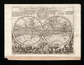
English: Title: A New Map of the Whole World with the Trade Winds... |
|||||||||||||||||||||||
| Datum | ||||||||||||||||||||||||
| Quell | Atlas Minor, 3rd ed. (London) | |||||||||||||||||||||||
| Auteur |
|
|||||||||||||||||||||||
| Aner Versiounen |
|
|||||||||||||||||||||||


_-_region_Indian_Ocean-New_Holland-Dimens_Land.png)
Lizenz
|
Der Urheber dieses Werks ist 1732 gestorben; es ist daher gemeinfrei, weil seine urheberrechtliche Schutzfrist abgelaufen ist. Dieses Werk ist gemeinfrei in den Vereinigten Staaten, weil es vor dem 1. Januar 1929 veröffentlicht (oder beim U.S. Copyright Office registriert) wurde. | |
| Dëse Fichier gouf als fräi an ouni iergendeng bekannt Restriktioun vu Copyrightrechter, inklusiv vun alle verbonnenen oder änleche Rechter, identifizéiert. | |
Versiounen
Klickt op e bestëmmten Zäitpunkt fir déi respektiv Versioun vum Fichier ze kucken.
| Versioun vum | Miniaturbild | Dimensiounen | Benotzer | Bemierkung | |
|---|---|---|---|---|---|
| aktuell | 16:06, 13. Sep. 2005 | | 1.400 × 1.083 (3,22 MB) | Frank Schulenburg | Herman Moll: ''A new map of the whole world with the trade winds'', 1736 {{Creator:Herman Moll}} Category:18th century maps |
Benotze vu Fichieren
Dës Säit benotzt dëse Fichier:
Globaalt Benotze vum Fichier
Dës aner Wikie benotzen dëse Fichier:
- Benotzt op ca.wikipedia.org
- Benotzt op cs.wikipedia.org
- Benotzt op de.wikipedia.org
- Benotzt op de.wikiversity.org
- Benotzt op en.wikipedia.org
- Benotzt op eo.wikipedia.org
- Benotzt op es.wikipedia.org
- Benotzt op fa.wikipedia.org
- Benotzt op fr.wikipedia.org
- Benotzt op he.wikipedia.org
- Benotzt op pl.wikipedia.org
- Benotzt op pt.wikipedia.org
- Benotzt op simple.wikipedia.org
- Benotzt op tr.wikipedia.org